Hurricanes are powerful – and they also hold great mysteries. UMBC researcher Jeffrey Halverson uses the latest technology in collaboration with NASA to unlock those secrets and make potential storm victims safer.
By Jack Williams
Hurricanes as strong as the infamous Hurricane Katrina which ravaged New Orleans and the coast of the Gulf of Mexico in 2005 rarely hit the Delmarva area. But as Hurricane Isabel showed in 2003, a hurricane – even a storm that is weakening – can cause serious damage to our region.
Isabel’s power pushed water up the Chesapeake Bay to flood Fells Point and the Inner Harbor in Baltimore. It also damaged many buildings at the U.S. Naval Academy and in other parts of Annapolis. The cost of Isabel’s flooding and wind in Maryland and Washington, D.C. was estimated at $945 million – but fortunately only one death was reported.
Hurricanes such as Isabel and Katrina now cost the United States an average of $10 to $11 billion a year, and yet the population of coastal areas frequented by hurricanes continues to grow. And while Katrina was the deadliest and most expensive U.S. hurricane ever, a wide variety of storms have attracted close attention from hurricane researchers.
Some of that research is being done in the Joint Center for Earth Systems Technology (JCET), where associate director and UMBC associate professor of geography and environmental systems Jeffrey Halverson works with colleagues from NASA to tackle questions about hurricanes that could help save lives.
JCET is a joint effort between UMBC and NASA’s Goddard Space Flight Center, and the center’s researchers have the advantage of possessing some of the latest technology available to help guide their search for
answers. One of the most pressing questions that Halverson and his colleagues are trying to solve is what information forecasters need to better predict when a hurricane will intensify quickly and become that much more dangerous.
Since the 1950s, scientists have learned enough to enable forecasters to do a much better job of predicting where a hurricane is likely to go. But Halverson observes that “there has not been much progress in forecasting intensity changes.”
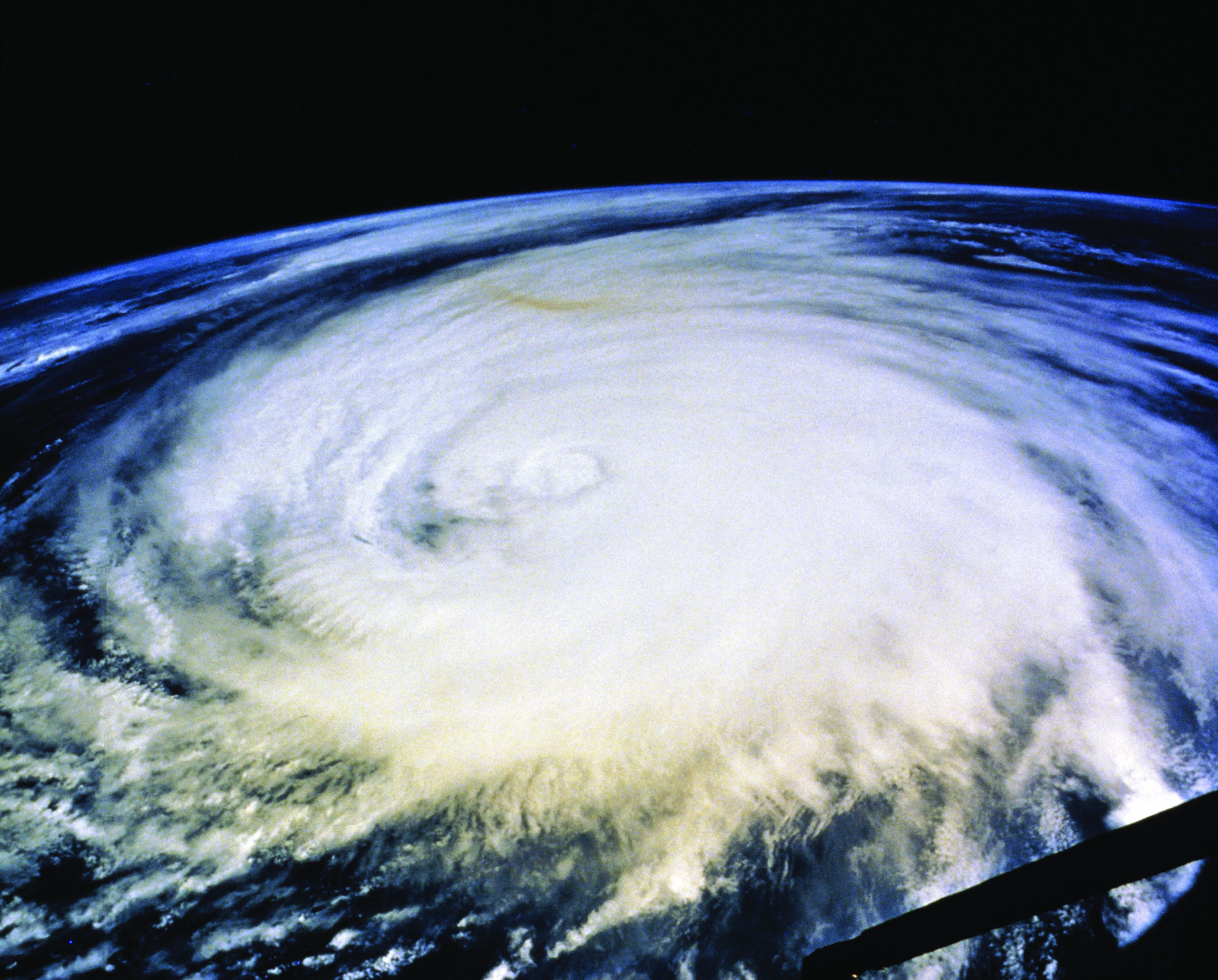
Hurricane Wilma’s ferocious journey over the Caribbean Sea in October 2005 illustrates just what can happen when storms suddenly gain power. In a mere 24 hours, Wilma strengthened from a 69 mph tropical storm to a 172 mph Category 5 hurricane. Fortunately, Wilma’s winds then weakened to 150 mph before the storm hit the Mexican island of Cozumel and then Cancun two days after reaching peak strength, and those precious 48 hours gave local governments time to move thousands of residents and tourists out of harm’s way.
The nightmare for hurricane forecasters is a storm like Wilma that kills hundreds of people after strengthening with little or no warning, leaving government officials and residents in a populated area only hours – instead of days – of warning.
In order to help forecasters better predict when a hurricane will intensify in an explosive fashion, scientists such as Halverson need to learn exactly what happens before a storm begins to grow into a monster, how to detect precursors to intensification, and then update forecasting computer models to handle the new data.
“The storm speaks to us in code that we’re trying to understand,” Halverson says.
Scientists armed with technology have already cracked some of the code. Global-scale winds at levels of up to 30,000 feet steer a hurricane across the ocean and land, and forecasts that track storms have improved as scientists learned more about how hurricanes interact with these winds. Forecasts of how winds will change
during a hurricane’s life have also improved. Indeed, many outside factors – especially the temperature of the ocean over which a hurricane is moving and the speeds and directions of global-scale winds around it – help determine when a hurricane will weaken or strengthen.
Scientists still need to learn more about what happens inside a storm that’s about to intensify. This part of the code is difficult because a hurricane is a cauldron of rising and sinking air moving in horizontal and vertical swirls ranging in size from inches across to the hundred-miles or larger diameter of wind spiraling into the storm. Water is changing among its vapor, liquid and ice phases to warm or cool rising and falling air. The moving air and changing temperatures are all interacting in ways that aren’t always clear.
“There is a lot of the physics we don’t understand,” Halverson admits. “We are trying to adapt new technologies to answer these questions.”
Up Up And Away
One way to get closer to the physics of hurricanes is to get physically closer to them – close enough to measure. Often the best way to research bad weather is in an airplane.
Halverson began conducting weather research from airplanes even before earning his Ph.D. in environmental science from the University of Virginia in 1995.
From November 1993 to February 1994, he worked aboard a NASA DC-8 research airplane as the scientist in charge of the cylindrical packages of instruments called dropsondes – sometimes described as “Pringles cans with microprocessors and parachutes.” After being dropped from an airplane, a dropsonde radios back data on temperatures, humidity and air pressure as it falls to the ocean. (In recent years, dropsondes have also been fitted with GPS receivers and have added wind speed and direction data to the data they send back as they descend.)
In addition to his time spent on that NASA DC-8 and on other airplanes, Halverson has also conducted weather research on ships, and worked in the jungles of the Solomon Islands in the South Pacific studying El Niño – the chain of ocean-atmospheric events that can affect weather around the globe – which begins with a cooling of the same western tropical Pacific Ocean where Halverson and other scientists conducted their 1993-94 research.
That project is a model for how meteorological research has been conducted since the 1950s. Groups of scientists begin by observing the weather with sophisticated instruments and then use the data to form hypotheses. Halverson adds that computer models and satellite monitoring have also become an important part of the process.
Halverson’s scientific career boasts a direct link to Bob and Joanne Simpson, the pioneers of airborne hurricane research and computer weather models. Halverson did postdoctoral work with Joanne Simpson at NASA in the mid-to-late-1990s, and has also worked on projects with Bob Simpson.
In an April 2005 talk given at an Explorers Club dinner in Washington, D.C., Halverson acknowledged the Simpsons in the audience, observing that Bob Simpson’s invention of hurricane-research flying “led to a great deal of what scientists know about hurricanes that no one knew before the 1950s. All of the brilliant research started with getting eyeballs into storms.” He also noted that Joanne Simpson was not only the first woman to earn a Ph.D. in meteorology, but also the first person to develop a computer model of what happens in a cumulus cloud.
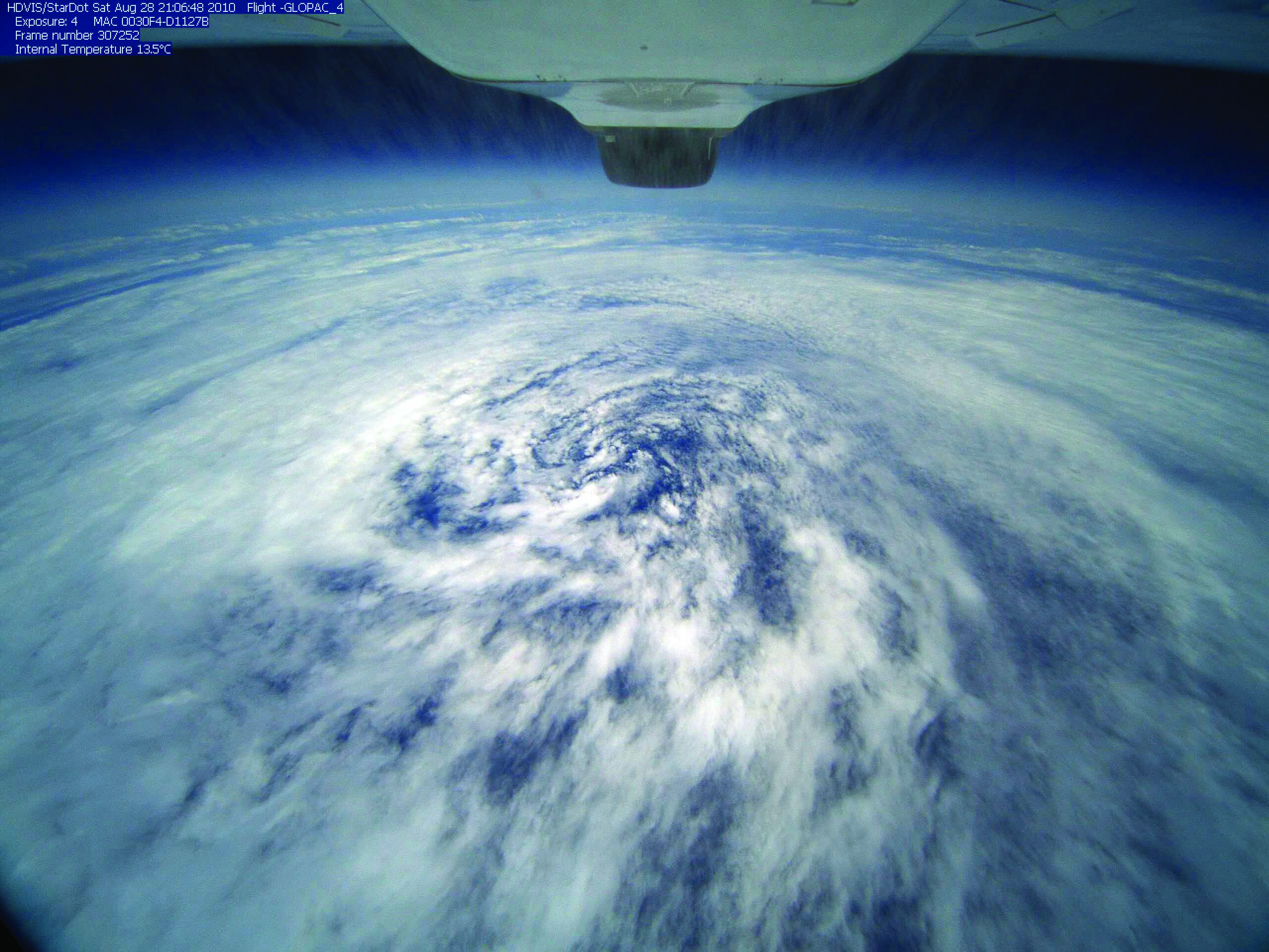
These days, Halverson is pushing the Simpsons’ legacy of innovation into the future. He is now a project scientist for the next big step in airborne hurricane research: sending the unmanned NASA Global Hawk airplane above the tops of hurricanes to help study their formation and intensification. He says 2010 “was the first time we flew the Global Hawk… it will revolutionize what we know about hurricanes… it’s the first time we’ll have a view from 65,000 feet over 25 hours. This will transform hurricane flying from reconnaissance to surveillance.”
The Global Hawk’s ability to stay in or above a storm longer than previous airplanes used for research is what is transforming the process from reconnaissance to surveillance. It is the latest tool for researchers in a wide range of airplanes used for big projects, including NASA’s DC-8, an ER-2 (NASA’s version of the U-2 spy plane), two WB-57s (a 1950s bomber now carrying research instruments), and the National Oceanic and Atmospheric Administration (NOAA)’s two WP-3 turboprops.
All of these airplanes maneuver inside or above a storm at the same time, but at different altitudes, to capture a more complete picture of what’s happening. The NOAA WP-3s slice through a hurricane’s eye 5,000 to 10,000 feet above the ocean, while the DC-8 flies at 40,000 feet on top of the storm and the ER-2 or the WB-57s soar high above the top. Depending on how far a storm is from the airplanes’ land bases, they all might be able to spend only the same two or three hours in a storm with the rest of their six- to ten-hour trips flying to and from the storm.
The Global Hawk, on the other hand, can stay in the air as long as 25 hours with its pilots at computers back at the missions base who work in shifts to keep the Hawk flying.
Halverson was a mission scientist for a NASA experiment in August and September 2010 that used the Global Hawk. It examined the formation and strengthening of storms in the Gulf of Mexico and western Atlantic Ocean. One Global Hawk flight included 20 passes over the eye of Hurricane Carl. NASA’s DC-8, a WB-57 and the Global Hawk also flew together on several data-collection flights.
“This has the possibility of reinventing what we do” says Halverson, who’ll be working with the Hawk as a member of the science team for NASA’s “Hurricane and Severe Storms Sentinel” mission from 2012 to 2014 to study hurricane genesis and intensity changes.
Few But Deadly: Why?
The “genesis” part of NASA’s “Hurricane and Severe Storms Sentinel” mission is a continuing quest to answer a question that Joanne Simpson and her colleagues asked more than 50 years ago: “Why are there so few hurricanes?”
The essential conditions needed for a tropical storm to form and grow into a 74 mph or faster hurricane for hurricane formation – including 80-degree-plus ocean water that’s at least 150 feet deep – are present for half of each year over many parts of the tropical Atlantic Ocean, the Caribbean Sea and the Gulf of Mexico.
Each year, 80 to 90 minor disturbances dubbed “easterly waves” move off Africa and traverse the Atlantic Ocean, but only a mere 10 to 12 of these actually spawn hurricanes. The easterly waves also offer no obvious clues that this is going to happen.
In the new mission, researchers will use two Global Hawks operating from NASA’s Wallops Island Flight Facility on the Virginia coast near Chincoteague during the 2012 through 2014 Atlantic hurricane seasons.
Those easterly waves are a key question for researchers. “Is there something about a seedling that makes it develop?” Halverson asks. “Is there something coming off Africa that gives it a head start?”
Halverson and other researchers believe that the answers to these questions and to why hurricanes sometimes intensify as quickly as Hurricane Wilma did are probably related. And that’s where the Global Hawk may provide new clues to formation and intensification. “If you’re not out there over time,” Halverson observes, “you miss what could be important parts of what happens to cause a hurricane to form or strengthen. With two Hawks, each flying for 25 hours, one can be going out to a storm as the other is coming in. We won’t miss a thing.”
Halverson adds that one of the lures of scholarship is sharing his work not only with other scientists through technical articles for scientific journals, but also with the general public.
“I enjoy enchanting others with science,” he says. And his radio and television interviews for the National Geographic Channel, the Discovery Channel and the Voice of America have been key avenues in doing so. Baltimore area television stations frequently call on Halverson for brief interviews when a hurricane is in the news.
Halverson has written a monthly column for Weatherwise Magazine – a publication targeted at general readers interested in the weather – for seven years. He also wrote the foreword and scientific sections of Stefan Bechtel’s 2006 book Roar of the Heavens: Surviving Hurricane Camille, about the 1969 hurricane that killed 143 people on the Gulf of Mexico’s coast when it came ashore, and 113 more in Virginia, most in Nelson County, where 30 inches of rain on the mountains caused flash floods.
Halverson is also developing a digital museum exhibit on the meteorology of the Hurricane Camille flood in Nelson County for the county’s historical society. It explains in images and words non-scientists can understand how Camille, which was then a tropical depression with winds less than 39 mph, dumped enough rain to cause a level of erosion on some mountains that would normally take over 1,000 years to occur.
In trying to bring weather’s secrets to the wider masses, Halverson says his model is the late astronomer Carl Sagan, who helped popularize science through articles, books and the classic 1980 PBS series Cosmos: A Personal Voyage.
“[Sagan] was one of my heroes,” Halverson says. “I’m part of the generation of kids he inspired. If I can do that, it will be a great service.”
Images courtesy of NASA
Tags: Summer 2011